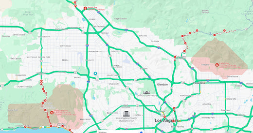
The Eaton Fire, which started in the eastern inland area of LA County on January 7, has been spreading across Southern California for a week, driven by strong winds.
As of January 14, at least 24 people have died from this wildfire, more than 40,000 acres of the Greater Los Angeles area have been damaged by fire, and more than 12,300 buildings have been destroyed.
In particular, the largest fire, the Palisades Fire, has burned more than 23,000 acres and is threatening Brentwood, Encino, and Westwood, but is only about 18% contained.
Currently, 88,000 Los Angeles residents are under evacuation orders, and 89,000 are in evacuation warning areas.
This is an emergency situation that may require immediate evacuation, so please check Google Maps and related maps and information in advance to save precious lives. Generally, the route guidance of navigation apps provided by Apple CarPlay or Android Auto reflects information such as real-time traffic conditions, road closures, and accidents.
Therefore, in the case of emergency situations such as wildfires in the LA area, Google Maps may also reflect data provided by organizations such as the California Department of Transportation or the California Fire Department, and provide guidance on road closures or detours due to wildfires.
However, the accuracy and up-to-dateness of this information may vary or may not yet be reflected depending on the data update cycle of the CarPlay app and the information provided by the LA area traffic authorities.
Therefore, in emergency evacuation situations, be sure to check the latest information through local official traffic information or news in addition to CarPlay route guidance information.
- Palisades : 23000 acres ( 7 days / 18% contained )
- Eaton : 14000 acres ( 7 days / 35% contained )
- Hurst : 800 acres ( 6 days / 97% contained )

Palisades fire track on Google Maps

Eaton fire track on Google Maps

Hurst fire track on Google Maps

